Thursday, October 11, 2018

Heading Down Delaware Bay - Post 2

Delaware Bay has the reputation of being a difficult body of water to traverse for several reasons. There is a lot of commercial traffic with cargo ships and barges and it is a very shallow body of water which can be problematic, particularly for deep draft vessels. Lastly, the current can really make for a challenging trip, particularly for sailboats.

Rosalind

The distance from our anchorage just outside the C&D Canal to Cape May, New Jersey, was between 52 and 57 nautical miles (96 and 106 km) depending on whether we got to Cape May through the Cape May Canal or the ocean inlet. Our strategy was the following: get out at first light and head down the Bay as fast as we could. By doing so, we sacrificed the first two hours of favorable current but avoided starting out in complete darkness. Even though we have radar and receive automatic identification system (AIS) signals, we felt the risk of confusing aides to navigation with background lights was still significant. So we decided to start at first light and take the current/tides penalty at the end of the trip when we neared Cape May.

The unanticipated challenge was raising the anchor in almost 3 knots (5 km/h) of current. We had been warned to really set the anchor well to avoid dragging because of the swift current. Now we had the challenge of getting the anchor unstuck in that same swift current. It took us the better part of half an hour, and as soon as the anchor was dislodged, Cheryl had to get Rosalind pointed south and get some water flowing past the rudder in order to get some steerage. We had coordinated our plan and it all worked out; the anchor was up and we were soon heading south. Leaving the anchorage at first light was definitely a wise call as the area around Delaware City was full of shore lights and shipping traffic.

Main Channel Light #32 (with Northbound Current), Delaware Bay

We flew down Delaware Bay occasionally reaching 8 knots (15 km/h) via the combination of sails, motor, and current. Shipping traffic was light and visibility was good, and in early afternoon we were at the entrance of the Cape May Canal. This canal is much narrower than the C&D Canal, is shallower, and has a vertical clearance of 55 ft (17 m) limited by two fixed bridges. 

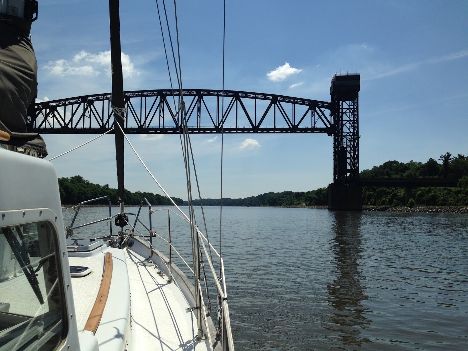
Cockpit, Motoring down Delaware Bay

We selected to go through the Canal, given our mast clearance of 46 ft (14 m). With strong current against us, it took a while to get through the 3 mile (6 km) canal. Going though the Canal was challenging not only because of the adverse current but because of the wakes caused by very fast moving powerboats. There are the remains of a old swing bridge in the canal, and while the bridge no longer needs to be negotiated vertically, there is only room for one way traffic between the remaining dolphins (foundations). Powerboats were flying in both directions and we had a particularly large boat pass us just before we got to the remnants of the old bridge. The wake caused a mess, tossing all 18,000 lbs (8,200 kg) of Rosalind for a wild ride and it took some effort to hang on. What was amazing was that the offending captain was completely unaware of the mess his wake was making and cheerfully waved to us as he zoomed by! It got a little hairy in the canal for a while but we were finally through it.

Lewes, Delaware to Cape May, New Jersey Ferry

When we left Galesville we were so excited to head out that we did not pay much attention to the calendar. So here we were heading into Cape May on the weekend before the Fourth of July. It was getting late in the day, and with the strong current, we were not about to go wandering around the congested harbor to look for a place to drop the hook. There is really only one good anchorage with limited space. So, with the holiday approaching, we decided not to take a chance but to see if we could get a marina for a day or two to provision and stage for our offshore trip north. It took several calls but we finally found a marina that had a slip and enough water to accommodate our five foot (1.5 m) draft.

Thursday, October 4, 2018

Heading out for our Summer Cruise - Post 1

Over the next fourteen weeks we will be sharing with you our 2018 summer cruise. We will be posting once a week. We hope you enjoy the posts.

June 25, 2018 
It's 8:30 pm and we are at our mooring on the West River. The temperature in the salon is still 82F (28C) but in the V-berth the evening breeze provides a gentle freshness. Outside the temperature is balmy. Tomorrow we are leaving our mooring for new harbors and new acquaintances. It’s more than exciting. It has taken lots of work and tons of flexibility to get to this point. 

After spending nearly a year refurbishing Rosalind in 2016, we wanted to head south that year. Some unexpected engine room work pushed back our departure until it got too cold to leave that season. Then, we tried going north the following summer but our plans were forced to change. In the fall, work intervened and changed our plans to go south that year too. Now we are going north, heading out almost two years later than originally planned.

Rosalind

It’s been a long road, but we have learned a lot along the way. We have learned how to live on board and have made a number of important improvements to Rosalind. But we have also learned to really enjoy the process, because at the end of the day, that really is cruising.

June 26, 2018
The weather window that we were waiting for had arrived. Mid-morning on Tuesday, June 26th, we picked up our mooring pennant and headed north on the Chesapeake Bay. The light following winds and seas with assistance from Lucy, our trusted Beta 30 horsepower engine, pushed us up the Bay. We passed Thomas Point Light and before long we were passing Annapolis, the furthest north we had ever sailed until now.  

Chesapeake Bay Bridge

On the VHF radio there was a report of a school of dolphins spotted in the Chesapeake and we took that as a great omen for our cruise. Soon after, we passed under the Bay Bridge and turned east. The wind picked up from zero to 10 knots (0 to 19 km/h) in a matter of minutes, then it went up to 15 knots (28 km/h). We took advantage of the afternoon bay breeze and we had a beautiful sail to the Magothy River entrance. When we reached our destination and anchored in the Magothy River, the wind quickly rose to over 20 knots (37 km/h).

Over the years we had heard great stories about the Magothy and we were soon to discover what a special place the Magothy really is. We anchored in Forked Creek in 14 ft (4 m) of water and enjoyed a great dinner with a spectacular sunset while Rosalind rode out the strong breeze at anchor with her anchor riding sail. 

Sunset, Magothy River, Chesapeake Bay

It's been a day of firsts for us: 
  • First time under the Chesapeake Bay Bridge
  • First time in the Magothy River
  • First time this far north

June 27, 2018
A weather front with strong thunderstorms was moving through the area so we decided to stay an extra day in the Magothy River. We stayed on board and worked on the port hardtop handle in the morning then, after lunch, we listened to podcasts and relaxed. 

June 28, 2018
We left the Magothy River and headed northeast across the Bay to Worton Creek. After 25 miles (46 km) we arrived in Worton Creek where, after setting the anchor and getting Rosalind organized, I jumped overboard for a swim. This far north, the Bay is almost entirely fresh water. The water was a beautiful green color and we could see halfway down the rudder. I had been in the Bay before to clean our prop (not a pleasant experience when you cannot see your extended arm!), but this was my first “pleasure” swim in the Bay. The swim was refreshing and I ended up swimming twice that afternoon as the Mid-Atlantic was starting to see the beginnings of a nationwide heatwave. We shared Worton Creek with a couple of other sailboats, had a great evening, and were again treated to a beautiful sunset and moonrise.

Motorsailing past Baltimore Light towards Worton Creek

June 29, 2018
We had to plan the next leg of the trip carefully because of the strong currents at the top of the Bay and particularly through the Chesapeake & Delaware (C&D) Canal. After consulting Eldridge, the nautical publication that has been providing tides and current information since 1875, we decided that we needed to get out of Worton Creek at first light if we wanted to make it to Chesapeake City without having to fight the current.

We got up before sunrise and at 5:35 am raised anchor and headed north towards the C&D Canal. The C&D Canal links the two namesake bays and offers a shortcut for both commercial and pleasure boats. The Canal is very well marked and is also lit for night transits. Our destination was Chesapeake City, 3 miles (5 km) into the Canal where there is a small anchorage. Chesapeake City is an interesting destination on its own and we planned to stage there in order to get a fair current to transit the remaining 12 miles (22 km) of the Canal. 

The current was with us all the way that day and we flew up the Chesapeake, at times reaching over 7 knots (13 km/h) instead of our normal cruising speed of 5 knots (9 km/h). As we were approaching Chesapeake City we concluded that we should be able to make a run for it and get through the C&D Canal all in one go with about an hour left over before the tide turned. We motored by Chesapeake City, leaving it to explore at another day, and shortly after noon we were in the Delaware Bay.

Conrail Lift Bridge, C&D Canal

We anchored just outside of the Canal in 23 ft (7 m) of water at almost slack water. It was very hot, in the 90s (32+C), so we had cold showers on deck to cool off. By three in the afternoon, the water was flowing by Rosalind at almost 3 knots (6 km/h). There was a light breeze on the water and it, together with the current, created an illusion that we were moving fast. It was a strange experience. We were treated to another beautiful sunset with no wind and slack water. We consulted Eldridge, planned our trip down Delaware Bay, and turned in early. We were going to have an early start (again!) to leverage the outgoing tide.

Sunset, Anchored off Delaware City, Delaware Bay